Ordnance Survey National Geographic Data
Unlock the most detailed view of UK properties and land
GBG Loqate’s integration of Ordnance Survey’s National Geographic Database (NGD) gives you access to the most comprehensive and authoritative location data in Great Britain. With over 500 million geographic features, NGD offers unmatched precision and insight into land, property, infrastructure, and environmental context updated daily.

What Is NGD?
The National Geographic Database is Ordnance Survey’s next-generation location dataset, combining high-precision mapping with rich property intelligence. It includes:
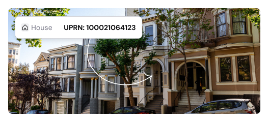
UPRNs (Unique Property Reference Numbers)
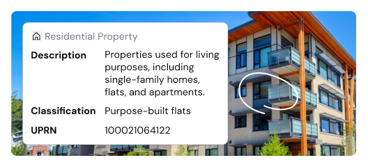
Detailed property classifications
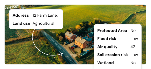
Environmental overlays and land use classifications
Historic and provisional address records

Why NGD from GBG Loqate?
As a trusted Ordnance Survey partner, GBG Loqate enhances NGD data with world-class address verification, geocoding, and location intelligence technology. Our solutions are relied on by global brands to improve delivery accuracy, reduce fraud, and streamline customer experiences.
 Unmatched Accuracy: Access over 39 million UK addresses, including Royal Mail PAF data, local authority records, and unique property insights.
 - Daily Updates: Stay current with address changes, new builds, and lifecycle data refreshed every 24 hours.
- Deep Property Intelligence: Go beyond basic addresses - understand property types, usage, and even non-addressable features like car parks, green spaces or phone boxes.
- Seamless Integration: Easily plug into your existing systems, CRMs, or GIS platforms with Loqate’s flexible APIs and data services.