What is a FIPS Code? Definition and FIPS Codes for States

Geographical data is more complex than one may think. And, believe it or not, it also serves numerous different use cases - far beyond getting letters delivered to the correct mailbox. For example, industries like finance, e-commerce, and travel rely heavily on geographical data for address verification to validate their customers, prevent fraud, and conduct market or customer analysis.
ZIP codes may be the most well-known of these, but they barely scratch the surface. Organizations and federal agencies use various standards to identify and organize geographical data. FIPS codes are one such standard, enabling the management of geographical data across the United States. Though officially withdrawn in 2008, FIPS codes are still prevalent and used across various organizations today.
What is a FIPS Code?
A FIPS code - or Federal Information Processing Standards code, to say it in full - is a standardized set of numeric digits that helps identify geographic zones within the United States. The National Institute of Standards and Technology (NIST) originally established these codes in 1965 to provide organizations with a standardized method to quickly identify states, counties, cities, and other locations.
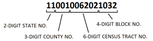
The number of digits and the code's format varies depending on the geographic entity they represent. For example:
- State FIPS codes are two-digit numbers from 0 to 50 (for example, New York is 36, Texas is 48, California is 06).
- County FIPS codes are five-digit combinations of the state code and a three-digit county code. For example, 06037 represents Los Angeles, California.
- Place FIPS codes (for cities and towns) and add another two digits to the existing five. For example, the FIPS code for New York City is 3651000.
FIPS codes were also assigned to other geographic entities, including military installations, metropolitan statistical areas (MSAs), congressional districts, and Native American reservations.
FIPS Code vs. ZIP Code
Like FIPS codes, ZIP codes also identify geographic areas. However, the two codes do serve different purposes. While FIPS codes primarily serve administrative, data analysis, and statistical purposes, ZIP codes were created by the US Postal Service to facilitate mail delivery. Therefore, they are mainly used for routing. Here are some key differences between the two:
|
Difference |
FIPS code |
ZIP code |
|
Created by |
National Institute of Standards and Technology (NIST) |
US Postal Service (USPS) |
|
Purpose |
Administrative and data analysis |
Mail delivery |
|
Scope |
Identifies states, counties, cities, and other locations |
Identifies postal delivery areas (specific residences or commercial buildings) |
|
Structure and length |
Numeric; from two to 10 digits depending on the level of detail |
Numeric; the first five digits identify the area, and the subsequent four digits identify the specific building |
|
Example |
36061 (New York County, NY) |
10001-2345 (with 10001 being the identifier for Manhattan, NY) |
From FIPS to GEOIDs and GNIS Codes
When FIPS codes were withdrawn in 2008, many public organizations had to seek other alternatives. The US Census Bureau and other agencies transitioned to using Geographic Identifiers (GEOIDs), which are numeric codes uniquely identifying legal or statistical geographic areas. They also leveraged Geographic Names Information System (GNIS) codes maintained by the U.S. Geological Survey (USGS).
But that didn't exactly spell the end of FIPS codes' usage. Due to their extensive use in government databases, emergency response systems, and mapping applications, FIPS codes are still referenced in various contexts today. For example, you may still see them in:
- Census data
- GIS mapping and address verification
- Local emergency management systems
- Federal grant distributions
To give another example, National Weather Service (NWS) uses FIPS codes to issue weather warnings and alerts, so emergency broadcasts accurately target specific regions. Similarly, FIPS codes are used in financial reporting, regulatory compliance, and voting district management, where precise geographic identification is necessary. More generally, state and local governments and other public organizations may still rely on FIPS codes simply for data consistency and record-keeping.
Your guide to FIPS Codes for States
We've pulled together a quick list of FIPS codes for each of the States, listed below:
|
State |
FIPS Code |
State |
FIPS Code |
|
Alabama |
01 |
Alaska |
02 |
|
Arizona |
04 |
Arkansas |
05 |
|
California |
06 |
Colorado |
08 |
|
Connecticut |
09 |
Delaware |
10 |
|
Florida |
12 |
Georgia |
13 |
|
Hawaii |
15 |
Idaho |
16 |
|
Illinois |
17 |
Indiana |
18 |
|
Iowa |
19 |
Kansas |
20 |
|
Kentucky |
21 |
Louisiana |
22 |
|
Maine |
23 |
Maryland |
24 |
|
Massachusetts |
25 |
Michigan |
26 |
|
Minnesota |
27 |
Mississippi |
28 |
|
Missouri |
29 |
Montana |
30 |
|
Nebraska |
31 |
Nevada |
32 |
|
New Hampshire |
33 |
New Jersey |
34 |
|
New Mexico |
35 |
New York |
36 |
|
North Carolina |
37 |
North Dakota |
38 |
|
Ohio |
39 |
Oklahoma |
40 |
|
Oregon |
41 |
Pennsylvania |
42 |
|
Rhode Island |
44 |
South Carolina |
45 |
Why is Location Accuracy Important?
As we've covered, there are numerous methods to identify geographic areas, from FIPS to GNIS, ZIP, and Census codes. Having ample options is great, but all these codes can cause confusion in data analysis and address verification. Regardless of the industry you operate in, data accuracy is likely a top priority for your business (and doubtless, the source of more than a few headaches too!).
For example, Fintech businesses need a way to verify customers' identities while creating their accounts or before making financial transactions. Address verification is one key method to verify the legitimacy of customers and transactions, reducing the risk of fraud and ensuring compliance with regulations such as ISO 20022. Meanwhile, e-commerce businesses need to ensure location accuracy to avoid parcels being delivered to the wrong address or lost in transit (a nightmare for customer service teams).
Between failed deliveries, the pressures of regulatory compliance, and the crippling threats of fraud, companies that operate online need a solution that effectively verifies customers addresses. But effectiveness is just one piece of the puzzle. They also need to make sure that the solution is seamless enough not to disrupt the user journey and checkout experience.
How Loqate Uses Location Intelligence
As a leader in address verification and geolocation solutions, Loqate collates updated geographic identifiers, such as Census Codes and GNIS Feature IDs, to enhance the precision of address data.
We don’t just have the richest globally curated data, though. Our Verify engine leverages unique parsing and matching technology to standardize addresses to local formats and ensure they are CASS, AMAS, and SERP certified. It also validates and verifies addresses across 250 countries and territories.
So, how does it work? It’s simple. Loqate can complete address form fields in just three milliseconds. Then, we use our AI parsing engine and platform-agnostic Verify API to verify address accuracy in real-time during a checkout or account opening process. We also have geocoding and reverse geocoding to analyze latitude and longitude data, making data verification even more precise.
With more than 3 billion address verifications each month by over 14,000 customers worldwide, Loqate is your expert address verification partner for businesses looking for seamless yet highly precise solutions that can scale with them. Explore more here.
Address Verification from Loqate
Find out more about how Loqate's Verify product verifies, corrects and enriches address data to the highest level of precision and confidence.
