How Does a Store Finder Work?
In principle, a Store Finder tool works by allowing you to combine precise location information for your organisation's stores and a customer's location, then determining the relationship between the two sets of information, and presenting the results in a visual fashion.
The key elements that you need in order to make a Store Finder work are:
- A list of locations (generally referring to your stores, but this could be any other locations relevant to your business and your customers such as collection points or drop-off lockers)
- Additional (optional) useful information about each location
- Your customer's current location
- A method for identifying which of your locations are closest to your customer - calculated using either distance or time metrics, depending on what your customer wants
- A method of visually presenting this information, and allowing the customer to select specific locations and see relevant information about each one
This sort of tool (or combinations of its components) can be used in lots of different ways, but for the purposes of this article we're going to focus on the Store Finder use case.
How do Loqate APIs interact to build a Store Finder?
The Loqate Store Finder product is comprised of a series of APIs which interact with each other to fulfil all of the steps mentioned above. In this section we'll go into a little more detail about how this works.
The APIs in question fall into the following categories (click on the links below if you want to read the relevant API reference documentation):
- Location Management:
- Global Geocoding
- Distance Finder
- Mapping
Here's a diagram to show how the APIs fit together in a finished Store Finder:
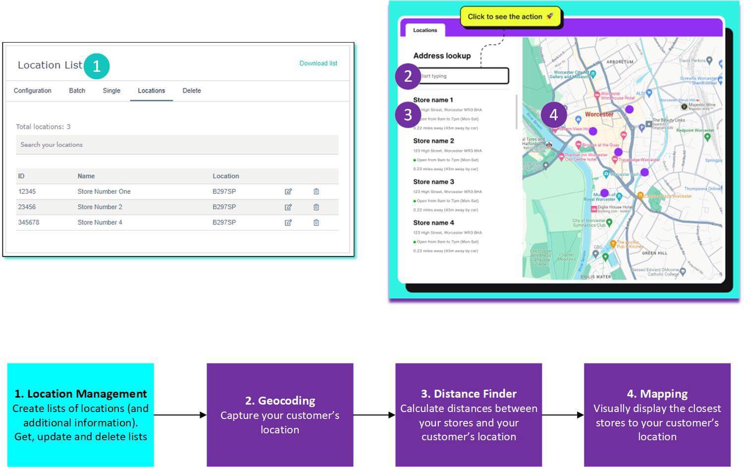
Let's take a closer look now at how they work.
Location Management
The first thing you need to decide where you will host your list of stores or locations that you want your customers to visit. There are three options for doing this:
- Upload one or more lists in a CSV format via your account (www.account.loqate.com). This method requires no technical skills, and is generally better for lists that don't need changing or updating frequently, and that you're happy to update manually
- Upload one or more lists via the Create List API. This method is generally better if you have a list that requires updating frequently, or you want to programmatically create and edit lists rather than doing this manually
- Host a list yourself or with a third party. If you don't want to send us your locations, or you already have them stored elsewhere, you can simply pass the co-ordinates of your locations (and any other optional information) to our Distance Finder API later on
Regardless of which method you choose, this list will form the basis of your Store Finder. At this point you can also append information about each store, such as opening hours, or contact details - this information can then be displayed to your customers at a later point.
It's crucial that we have co-ordinates for each of your stores, for use later on in the process. If you have addresses but not co-ordinates, don't worry - we can append them for you when you upload. You can either request this as a parameter when you call the Create List API, or select it as an option in your account.
If you need to make changes to any of your lists (or individual location points within one of them) then you can also do that, using one of the following APIs:
- Make changes using the Update List or Point API
- Delete lists you don't want/need any more using the Delete List or Point API
- See the details of all the locations within a list using the Get List API

If you have stores in multiple regions you can either create multiple lists for each region, or combine them into one. Creating multiple smaller lists can be beneficial to improve performance, and help manage different Store Finders for different countries.
Geocoding
Once you have at least one list of your stores, the next thing to do is to identify your customer's current location.
The Global Geocoding API takes a customer's address, post code or locality (inputted by the customer into an appropriate field on your website), and returns a set of co-ordinates identifying where that location is in the world.
You can then take these co-ordinates and pass them into our Distance Finder API in the next step.
Distance Finder
At this point in the process you have the locations of each of your stores, and the location of your end user. The next task is to identify which of your stores are closest to your customer, so that you can (in the next step) present the most appropriate options back to them.
We can can calculate this for you by passing the following two pieces of information into our Global Distance Finder API:
- The co-ordinates of your customer that you received from our Geocoding API
- Either the ID of your Location List, or the locations (via an array including ID, name and lat/long co-ordinates for each) that you have passed to use as part of the API request
This API will return all the stores within a given radius, along with any other information you have chosen to supply about those stores. It will also provide the road-based distance and travel time between your customer and each of your stores.
Road-based distances are preferential to straight line distance calculations, as they give a more realistic and precise view of how far away a store actually is. With straight line distances, geographic features such as bodies of water or non-traversable land are ignored, meaning that a customer could be pointed towards a store that isn't actually their closest one, giving them a worse experience.
Travel time is also a useful metric for customers as it allows them to quickly relate to the distances being shown. For example, if a store is 15 minutes away a customer can quickly determine whether they could make it there and back on their lunch break, increasing their chances of visiting the store.
You can then render these results as part of a side bar in your Store Finder, allowing users to see a list of your stores and any other relevant information.
Mapping
Lastly, you need a way of presenting this information to your end user on a map so that they can physically see where each store is located.
The Map Tile API allows you to retrieve map tiles for given co-ordinates. In combination with a map renderer library such as Maplibre or Leaflet this can be used to display your store locations on them. As we are only providing the basemap data and the tiles you are free to style your locations based on your own site design.
Want to know more?
We've linked out to the reference documentation for each API at the appropriate points on this page. Follow those links to read more about each of the individual APIs.
If you're ready to get started setting up your own Store Finder, read the guide on How to Implement a Store Finder.
For any further questions, please don't hesitate to contact the Loqate Support team.
